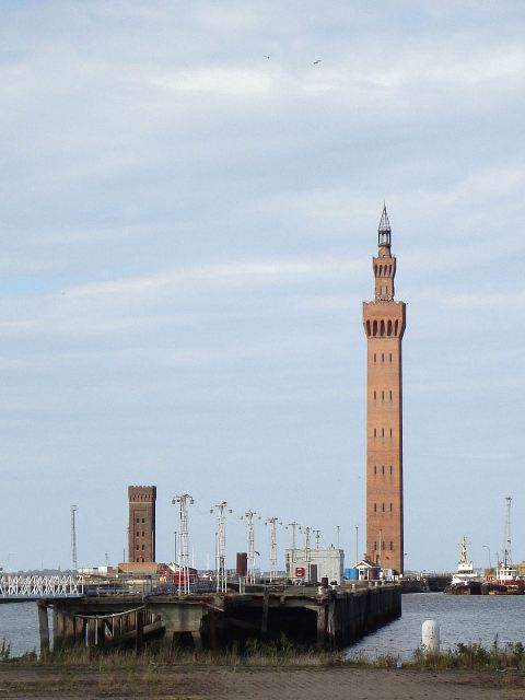
Immingham: the country’s biggest port by tonnage
The Port of Immingham handles around 56 million tonnes a year. A new eastern roll-on, roll-off terminal has been approved as nationally significant infrastructure, adding berths and capacity on the Humber. ABP’s Helm @ Immingham is now on site at Stallingborough Interchange: the first 103,000 sq ft of a 227-acre industrial scheme, with steel signed in June 2026 and completion of that first phase talked about for October. The town that lives next to that port still has to get its own bins collected, its own high street safe, and its own roads open. National infrastructure is not a substitute for a working town.
Industry & infrastructure
Official maritime paper
Immingham’s £20m Pride in Place money
Immingham and Habrough were awarded £20 million over ten years through the Government’s Pride in Place programme, with Stallingborough brought into the fund too. Pop-up events are asking residents how it should be spent. That is the right question for the full ten years, not just the launch photo. A port town that keeps the country’s fuel and goods moving deserves to see that money land on its own streets.
Economy & taxation
North Beck Bridge and the A1173
Works on the A1173 between King’s Road roundabout and Kiln Lane roundabout, including North Beck Bridge, began on 24 August 2026. The main phase, 1 September to 9 October 2026, is a 24-hour closure with diversions via the A160 and A180: bridge repairs, waterproofing, resurfacing. That stretch carries Immingham’s port traffic as well as everyone who lives there. Close it and the town feels it immediately.
Industry & infrastructure
Immingham town centre
Immingham held a public meeting in June 2026 with Humberside Police, the council and the local MP after concerns about anti-social behaviour, intimidation and alcohol-related disorder in the town centre. Residents and traders should be able to use their own streets. A meeting is a start. The test is whether it changes what people actually see.
Law & order
Goxhill and HGV traffic
Residents of South End, Goxhill, have been raising HGV traffic for years — including reports of dozens of lorry movements in an hour, and vehicles meeting on a road that cannot take them both. North Lincolnshire Council hired Pell Frischmann for traffic counts, then a further £6,300 report. A draft was due with the council in late February to early March 2026, with residents to be consulted. There has also been talk of trialling AutoHGVWatch ANPR cameras on weight limits. Meetings come and go. Villages on the way to the port are not a rat-run. They are places people live.
Industry & infrastructure
Brigg and the River Ancholme
Brigg is a market town where the Ancholme crosses the old road, with markets going back to a 13th-century charter. The river that made the town is also its recurring risk: flood alerts, monitored levels, and the town centre and leisure centre hit in the worst of them. Flood defence and drainage should not be an afterthought because Brigg is smaller than Grimsby.
Industry & infrastructure
Brigg’s banks leaving the high street
Lloyds closed its Brigg branch in March 2026. A temporary banking hub opened at The Angel; the permanent home is planned at The Buttercross. The council is right that a market town serving a wide rural area still needs cash and a face across a counter. Major banks walking off the high street is not a small-town luxury issue. It is how a town stays usable.
Economy & taxation
Brigg: another convenience store on the roundabout
Plans to turn the former Monument Garage on Bigby Road into a convenience store were refused, then came back. Dozens of residents objected, as did Brigg Town Council. Market towns do not need every spare plot turning into the same copy-and-paste store. Highways, parking and what the town actually wants should come before another chain frontage at the roundabout.
Economy & taxation
Barton: hundreds of homes, same GP list
Outline permission for up to 390 homes south of Horkstow Road was granted on appeal after councillors refused it. Persimmon has put in detailed plans for 388. A separate scheme for about 196 homes off Barrow Road, tied to a relief road, was refused by planning committee in March 2026 after objectors raised Anglian Water capacity, flood risk and “viability” cutting the developer contributions. Residents have kept raising the GP list in Barton. New houses without the surgery, school and road to match are not a gift to the town.
Healthcare
Barton’s Neighbourhood Plan
Barton sits at this branch’s northern edge, at the south end of the Humber Bridge. In November 2025 residents backed a Neighbourhood Plan by about 90 per cent. North Lincolnshire Council adopted it in December. That is the town saying how it wants to grow. Decisions made for Barton should start from that, not from what is convenient in a distant civic office.
Culture & identity
Humber Bridge safety works
Raised safety barriers on the Humber Bridge were approved in 2025. Detailed design then found the original wire system cannot be anchored at some points, including the Barton tower, so glass panels have been proposed in those stretches. The bridge is how Barton meets the rest of the country. Getting the works right, without leaving the south bank as an afterthought, matters here.
Industry & infrastructure
Broughton: housing and the A18 crossroads
Broughton sits inland of Brigg, on the way towards Scunthorpe — and this branch covers Broughton, not Scunthorpe. Housing west of Scawby Road has been going in; a temporary traffic order has closed stretches of Scawby Road for a new water main, with further closures in 2026. The busy A18 / B1207 Scawby and Broughton crossroads is getting four-way signals, lighting and resurfacing after it was identified as a collision priority. A town that takes the housing and the through-traffic should get a junction that works.
Restore Britain Broughton
Barnetby le Wold: the A180, the railway, and a lorry park on appeal
Barnetby sits on the noisy concrete A180 and the rail corridor that feeds Immingham. Network Rail opened an £8.8 million maintenance hub here in June 2026, bringing teams from Grimsby, Barnetby and Scunthorpe under one roof. The Government has also earmarked the A180 between Brocklesby and Barnetby Interchange for full reconstruction. At Barnetby Top (M180 Junction 5), a planning inspector in December 2025 allowed a lorry park of up to 200 bays, a fuel station and two drive-thrus after the council had refused it. Residents and Elsham Parish Council had raised flooding, queues on the slip road, and the edge of the Wolds. A village next to a motorway junction is not a blank sheet.
Restore Britain Barnetby le Wold
Elsham Tech Park: the AI data centre
This is not a rumour. On 11 March 2026 North Lincolnshire Council’s planning committee granted outline permission (PA/2025/643) for Elsham Tech Park, on farmland next to Elsham Wolds Industrial Estate — the old RAF airfield, about a mile from Elsham village and about a mile and a half from Barnetby Interchange (M180 Junction 5). The applicant is Elsham Tech Park Ltd. The scheme is for up to 15 data halls, about 1GW of IT load, backup generators and fuel stores, a district heating centre and greenhouses using waste heat. The site is about 176 hectares. An on-site energy centre is put at 49.9MW — so most of the power still has to come off the grid. Construction is talked about from 2027, with a first phase in 2029. The council talks of hundreds of long-term jobs and billions in investment. National Highways has been on the A15 and Barnetby Top traffic. A draft section 106 includes money for AI training and for parishes including Elsham, Worlaby, Wrawby, Barnetby le Wold, Goxhill and Barrow. Outline permission is not a finished building. Reserved matters still have to come back. Power, traffic and farmland at Elsham, Barnetby and Brigg are local questions. This branch covers Elsham. It does not cover Scunthorpe.
Barnetby le Wold
Official energy paper
Industry & infrastructure
Barton to New Holland: tidal flood defence
Homes in Barrow Haven, Barton-upon-Humber and New Holland sit on the Humber. North Lincolnshire Council put £1 million toward unlocking a roughly £39 million Environment Agency tidal scheme. About 50 of the highest-risk properties in Barrow Haven are in line for flood doors and non-return valves first, with embankments and outfalls to follow. Further public consultation is talked about for autumn 2026; the full business case is not expected until summer 2027. Flood defence here is not a distant climate lecture. It is whether the next high tide comes through the door.
Industry & infrastructure
Barton relief road
A mile-long relief road is meant to take traffic, especially HGVs, off Barton town centre by linking the A1077 / Barrow Road to Caistor Road. It is part of £19.7 million Levelling Up transport money. Site work has started, including a new roundabout. The council now says completion is summer 2027, later than the previous March 2027 estimate, while utilities are diverted. HGV restrictions through the town are being lined up to match the new road. A relief road that slips is not a gift until it is open and the lorries actually leave the High Street.
Industry & infrastructure
Barton roads and the station
In August 2026 the council announced months of works on Barton junctions, walking and cycling links and access to the railway station — Whitecross Street, Tofts Road, Barrow Road, High Street, Hungate and the Forkedale roundabout among them. There will be inconvenience. The test is whether school routes, the town centre and Waters’ Edge actually get safer, and whether the south bank is treated as worth doing properly.
Industry & infrastructure
Two councils, one branch
South Humber people are split between North East Lincolnshire and North Lincolnshire councils. In July 2026 the Government confirmed both stay as separate unitaries. This branch covers Broughton. It does not cover Scunthorpe or north of Scunthorpe. Whichever council collects your bin, services should work for the people paying for them.
Industry & infrastructure